
01
Which way would you go?
If you had to travel from the coast towards the interior, look at the mountains and valleys. Where does the landscape seem to open up?
Over the last few days, I have been preparing some routes for my guests who would like to leave Tarragona for a while and discover more of the countryside around us.
I started by following the rivers. Then came the vineyards and the different wine regions, the Cistercian monasteries, some of the villages and, eventually, the castles.
And the more I tried to separate one route from another, the more difficult it became.
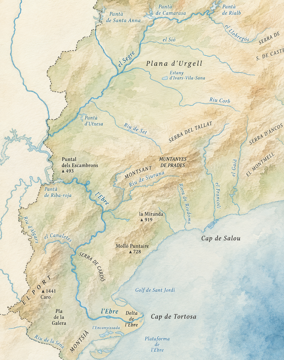
Before adding roads, farmland, villages or castles: the land, the mountains and the water.
I think we often visit places as though everything existed separately.
We arrive at a castle, visit it and move on. We enter a monastery. We see a beautiful village. We taste a wine. We cross a valley.
Each of these things can be interesting in its own right. But when we look at them in isolation, it becomes much harder to understand why they are precisely where they are.
Why did a town grow here rather than a few kilometres away? Why was some land cultivated while other areas remained wooded? Why do we find so many castles in certain places? Why was a monastery established in one particular valley?
While preparing these routes, I began to wonder whether, before looking for the answers in the buildings, I should first look at what had already been here long before any of them.
The land.
Sometimes we need to step back from what we are looking at in order to understand it better.
Imagine for a moment that the roads we know, the towns, the monasteries and the castles do not yet exist.
If you had to travel from the coast towards the interior, look at the mountains and valleys. Where does the landscape seem to open up?
You need water, land you can work and some way of communicating with other places. Which areas would you choose?
If you wanted to control who entered a valley or crossed a pass, where would it make sense to position yourself?
Once we add the main natural corridors, the map begins to look different.
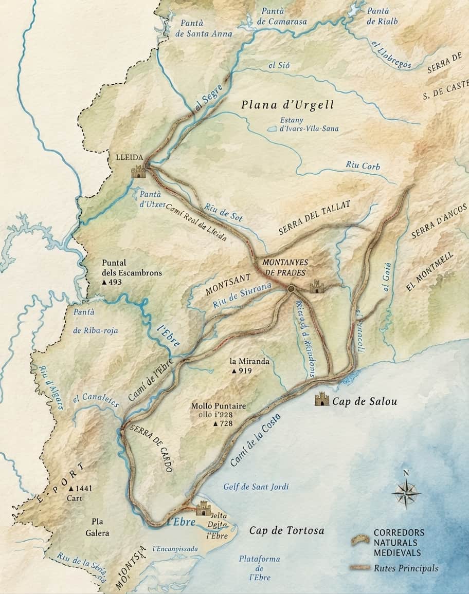
From Tarragona, the Francolí valley provides a natural route towards the interior. The river cuts through the relief, passes through the narrow area around La Riba and then opens into the Conca de Barberà.
Long before our modern roads existed, the shape of the land already influenced where travelling was easier. Different periods repeatedly made use of these natural corridors.
The Tarragona–Francolí–Conca–Lleida axis is a good example. History did not create the valley first: the valley was already there.
If the route is beginning to make sense, what happens when we add the land where people could live and produce food?
Moving is one necessity.
But staying somewhere requires something more.
Now we add the areas of cultivation and some of the great monastic centres.
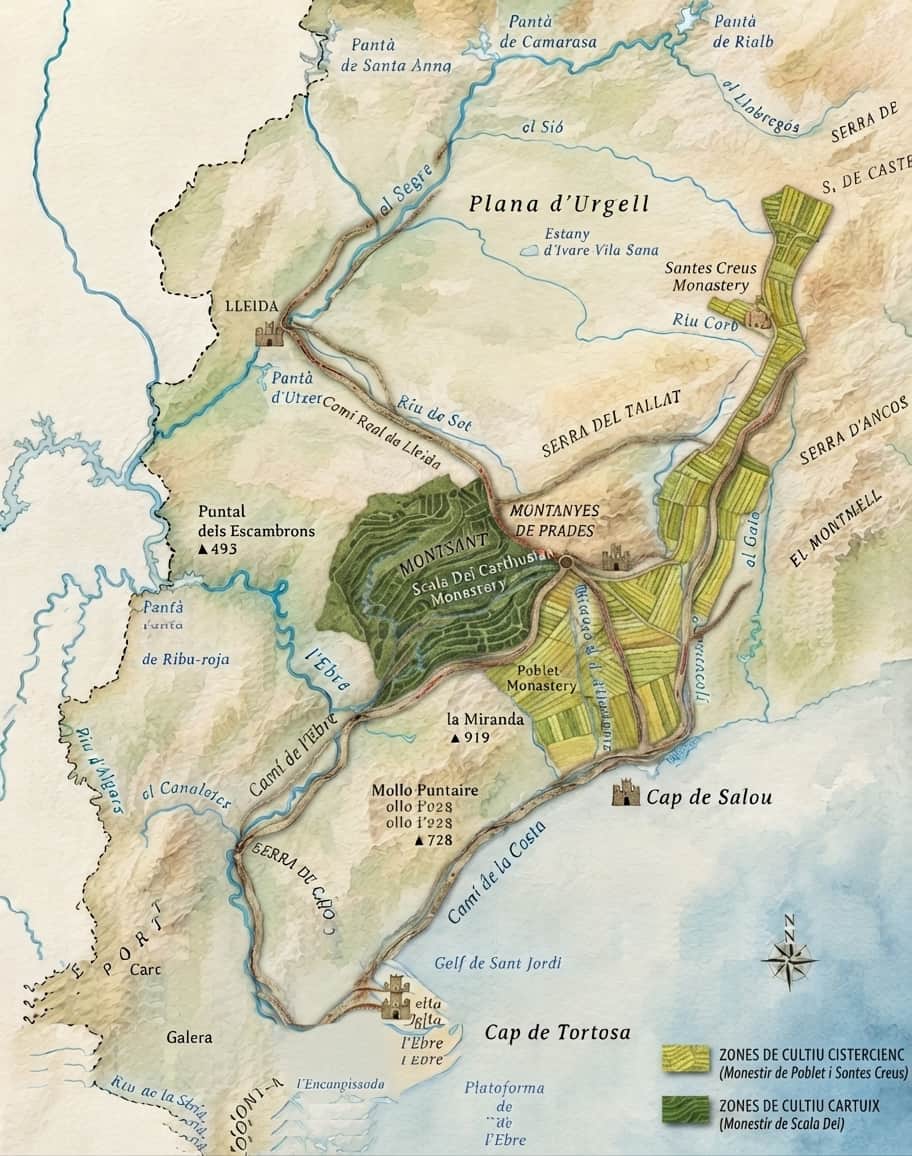
When we look at monasteries only as monuments, it is easy to forget the landscape surrounding them.
Poblet, Santes Creus and Vallbona de les Monges were part of landscapes where water, land, agricultural work and communications all mattered enormously.
The same idea helps when looking at Priorat. Its mountains, slopes and soils help explain why its agricultural landscape is so different from that of a plain.
Geography alone does not explain history. But once we can see it, many human decisions begin to feel much less arbitrary.
And if we now have routes, productive land and inhabited places... what would we want to protect or control?
The landscape now has routes to connect, land to produce and places worth protecting.
↓Only now do we add a few fortified places connected with passes, valleys and commanding positions.
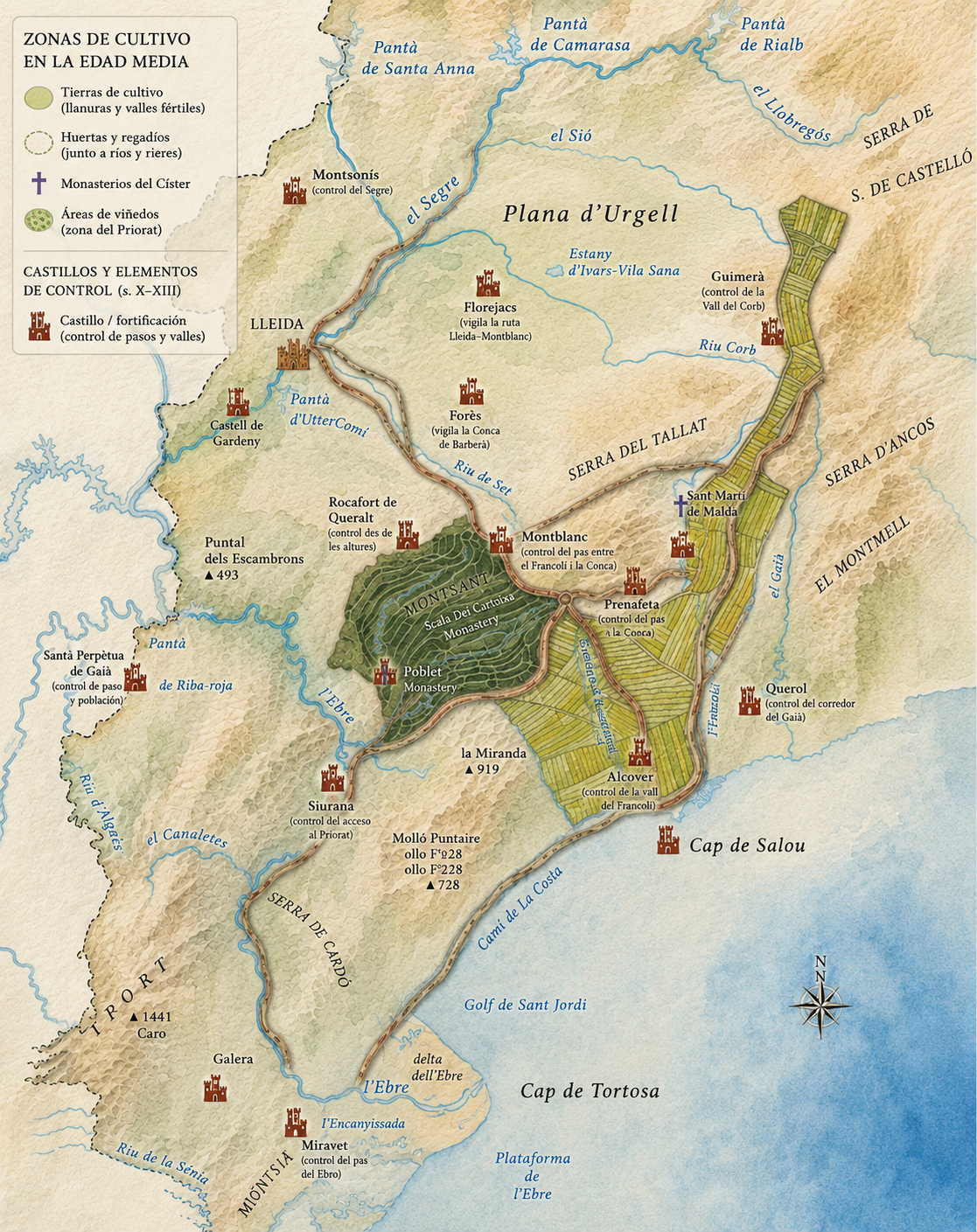
This was perhaps the part that changed most the way I looked at some of these places.
When we see a castle on its own, we see a ruin, a tower or perhaps somewhere to stop for a photograph.
But once we place it on the terrain, alongside the routes and valleys, the question changes completely:
What could they see from there?
Some positions could help control a pass. Others overlooked a valley or settlement. From certain heights, a much wider area could be observed.
Not every place needed to serve the same purpose. Sometimes, one carefully chosen position could overlook a pass or a surprisingly large area.
What first looked like several different routes begins to become one story.
We tend to put things into separate boxes. History in one. Geography in another. Wine, architecture, agriculture, villages, monasteries and castles as different subjects.
It is a convenient way to learn about them, but sometimes it prevents us from seeing something much more interesting: the relationships between them.
A mountain influences a route. A river makes cultivation possible. A valley makes movement easier. A route can favour certain settlements. And if a passage becomes important, someone may want to watch or control it.
Of course, human history is far more complicated than this. Politics, wars, trade, religion, technology and many other factors all play their part.
But underneath them is something that changes much more slowly: the land itself.
The excursions I had been preparing began to feel like different ways of entering the same story.
To discover how water opens valleys, accompanies villages and helps shape the way the territory is organised.
A ROUTE I AM CURRENTLY PREPARINGTo understand why Conca de Barberà, Montsant and Priorat can produce such different landscapes and wines within relatively short distances.
DISCOVER THE VINEYARDS OF TARRAGONA →To visit Poblet, Santes Creus or Vallbona without separating their buildings from the fields, water and routes that surround them.
MORE TO EXPLORE FROM HERETo ask not only what a castle looks like, but why it was built precisely there and what could be seen from its position.
DISCOVER THE MEDIEVAL COUNTRY →
Perhaps they are not different routes at all.
Perhaps they are simply different ways
of reading the same piece of land.
I am not a historian or a geographer. This page simply began while I was looking for interesting places and routes to share with the people who stay with us.
The more I explored, the more I realised that I was becoming less interested in collecting places and more interested in understanding how they were connected.
So perhaps, when we visit a village, a monastery or a castle, there is something very simple we can do before going inside.
Turn around.
Look at the valley, the mountains, the river or the route in front of us.
Why here?
We may not know the answer. But I think that simply asking the question already changes the way we look at a place.
To understand the relief more clearly, I found the physical and hypsometric map produced by the Institut Cartogràfic i Geològic de Catalunya particularly useful.
EXPLORE THE ICGC PHYSICAL MAP →